Global Risk Dashboard | GRiD
Your single source of global risk intelligence
Harness the power of GRiD, Maplecroft’s flagship global risk intelligence platform, where geospatial data, mapping and expert insight converge to redefine the way you manage global risk.
GRiD takes a comprehensive approach to risk, by combining our industry leading portfolio of 190+ risk issues with expert analysis from our team of specialists to provide a unique, web-based, single source of global risk intelligence.
We’ve designed GRiD with you in mind; to help you quickly identify and understand risk around the world so you can rapidly make better business decisions.
See GRiD in action...
What you need to know about GRiD


Tailor-made for you
Easy to use interface
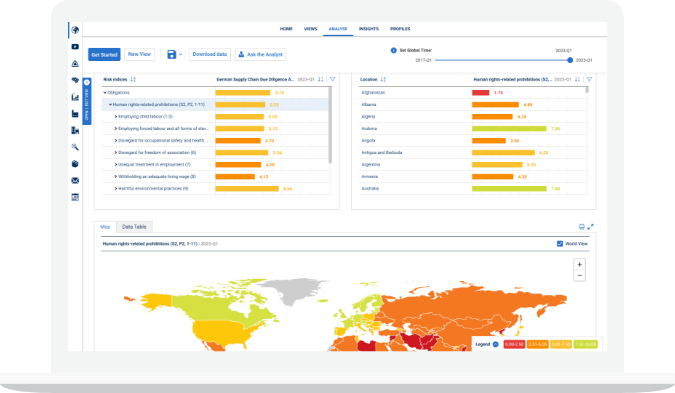
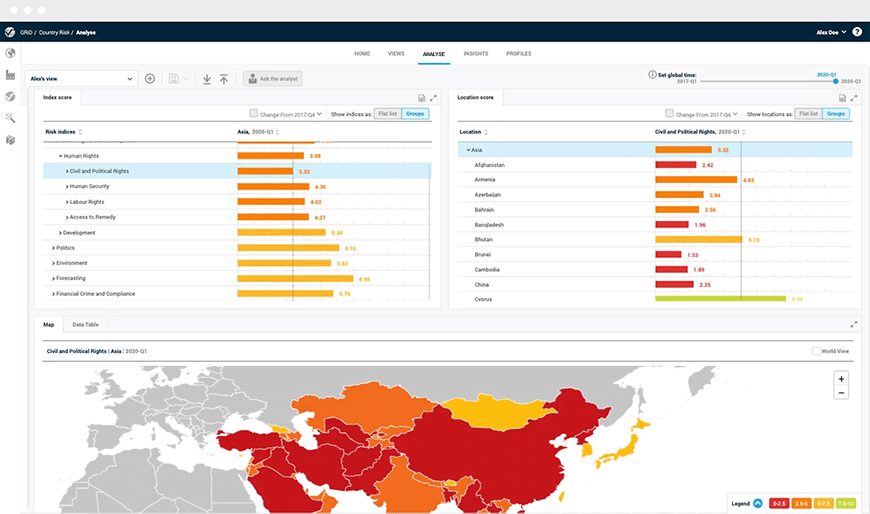
An intuitive interface with searchable risk indices, interactive maps and regularly updated data-led insights.
All in one place
A single source of intelligence, combining our 190+ risk issues, predictive analytics and expert insight.
Fully customisable
Build, customise and share tailored risk views. Combine your company data with our indices to compare risks across sites and create a view of risk that is unique to you.


Fully transparent
Get below the surface
Explore our index methodologies for 190+ risk issues. Dig into our 1200+ indicators to see what’s driving risk at a more granular level.
Timeseries
With up to 8 years’ data for our indices you can view our country and site scores over time to understand the trajectory of risk.
Support
Have questions on a country or issue? Connect with the right expert for quick, detailed analysis.
Alerts
Need to know when an index score changes? Receive email notifications and easily make comparisons between old and new scores.


Powerful analytics
Location uploads
Upload site, supplier and investment locations for more granular insights.
Data extract
Choose from a selection of download formats.
Global maps
View risk at a glance with interactive global maps, covering 190+ risk issues at national and subnational levels.
Our Maps
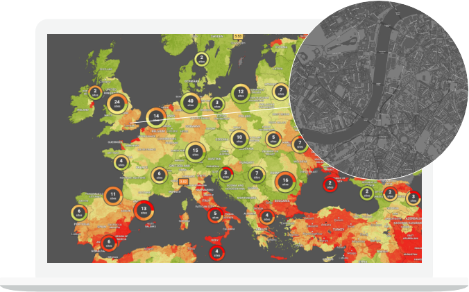
The GRiD mapping interface brings our Global Risk Data to life. Visualise your risk in granular detail with valuable subnational features including buildings, road names, and inland bodies of water, for any on-the-ground setting.
Unlock the power of our data
Precision
Interrogate our data with more precision and context by drilling down into your locations of interest.
Detail
Enhanced zoom functionality allows you to view subnational detail within tens of metres.
Overview
Donut charts help you cluster sites together and easily view the distributed risk across you locations.
Speed
Quickly delve into our subnational country risk indices and visually validate your locations’ risk score, before having to upload a site.
Validation
Validate your own location data – be confident your sites are in the right location by using the map layer as a reference.
FAQs
-
What are the advantages of using GRiD?
GRiD is built specifically for our customers and how they use our data. In addition to our proprietary data, detailed maps, and expert analysis, you get access to key information on our methodologies and underlying data sources including 1200+ indicators. Stay up to date with score changes with our alerts function and easily access our analysts if you have any questions about our data or specific risk issues.
-
Once I subscribe, will you show me how to get the most from GRiD?
Yes, on your first login you’ll see a quick start guide and the Learn section has been specifically designed to help you with key workflows. Our Client Success team are on hand to help you get the most from GRiD through our onboarding process. If you have questions, we are always quick to respond.
-
If I want to upload sensitive data into GRiD, what information security and protection measures do you have in place?
The security of our customer’s data is critical to us. We are trusted keepers of sensitive data for many of the world’s largest brands and businesses because we hold ourselves to the highest standards. If you'd like to know more about our Information Security Policy Framework, please get in touch.
-
I’d like to get your data through another platform. Do you have an API?
No problem! We have a developer API and connectors to BI tools like Power BI. We also offer our data via integrations with key internal (e.g. Verisk’s Touchstone, Sequel Impact) and external partners (e.g. ESRI’s Arc GIS, Assent Compliance). Get in touch and we can talk through the different options to find the best fit for your use case.
If you have a question about GRiD or any other product, you can get in touch through our contact page
Global Risk Data

Global Risk Data
Dashboards are only as good as the content driving them, learn about our Global Risk Data.
Featured
Delivery solutions

Featured
Delivery solutions
Our data your way
Global Risk Dashboard | GRiD demo request
Complete the form below and a member of our team will be in touch